Chassara Fm
Type Locality and Naming
OUTCROP. Named after Chassara (Chhasra) village. [Original Publication: Biswas, S.K. and Raju, D.S.N. (1971) Note on the rock stratigraphic classification of the Tertiary sediments of Kutch. Quart. Jour. Geol. Min. Met. Soc. India.]
Synonyms: Chhasra Fm. It was originally described as the Vinjhan Shale by Biswas and Raju (1971 and 1973); Raju 1974. Related names are: Argillaceous Group (Wynne, 1972), Gaj Series/Beds (Tewari, 1957; Poddar, 1959; Chatterjee and Mathur, 1966), Vinjhan Shale (Biswas and Raju, 1971) (Source: Pandey and Dave, 1998).
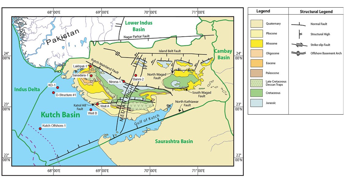
[Fig. Geological and structural map of Kutch, also showing the onshore and offshore wells drilled for oil exploration. (Map by Rasoul Sorkhabi in GeoExpro Dec2014, based on various sources including S.K. Biswas, Current Science, 25May2005)]
Lithology and Thickness
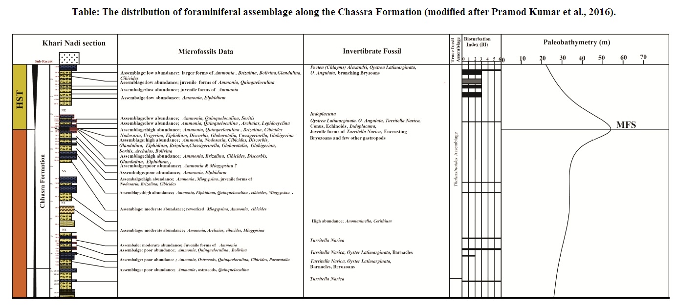
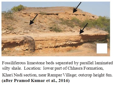
Shallow-marine marl. The Claystone Member of the Chassara Formation is characterized by highly fossiliferous limestone beds (30-75 cm) separated by silty shale/shale of variable thickness. The limestone beds are hard and compact, comprising of Turritella, echinoids, bryozoans, barnacles, oysters, serpulids and larger foraminifera. The skeletal elements are well-preserved in contrast to those of the Khari Nadi Formation. The soles of the limestone beds are either gradational/erosional or are bioturbated with Thalassinoides assemblage. The limestone beds are separated by parallel laminated silty shale (Fig under Outcrop photographs). The silty shales exhibit medium to high abundance of benthic foraminifera comprising Ammonia, Quinqueloculina and ostracods. In the middle part of the succession, thin limestone beds are intervened by shale. The limestones, petrographically classified as packstones, are 3-7 cm thick and are exceptionally rich in benthic foraminifer Ammonia. The intervening shales in this part yields high abundance of planktonic and benthic foraminifera
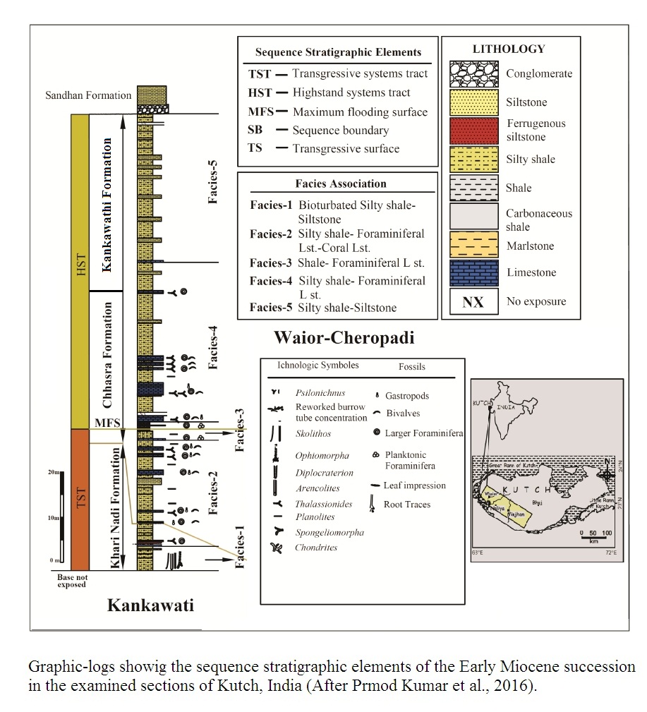
This Early Miocene sedimentary succession of Kutch records third order cycle of Vail et al. (1977a & b) and cycle of million year episodicity of Miall (2010). (Source: Pramod Kumar et al., 2016).
Maximum thickness encountered in the type section is 116 m.
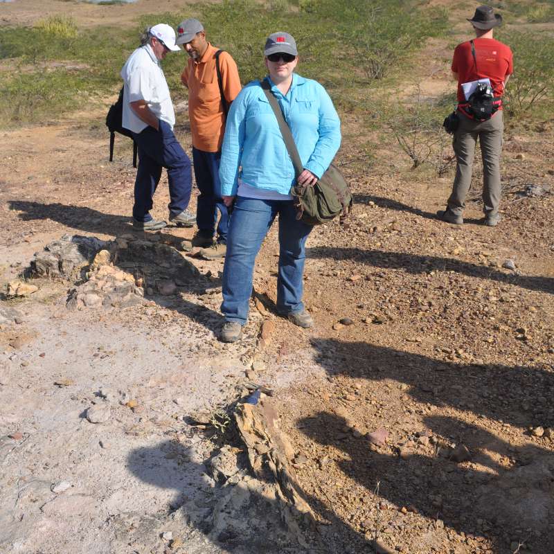
[Figure 1: Fossiliferous limestone beds separated by parallel laminated silty shale.
(Source: Pramod Kumar et al., 2016)]
[Figure 2: Graphic Logs showing the sequence stratigraphic elements of the early Miocene succession in the examined section of Kutch. (after Pramod Kumar et al., 2016)]
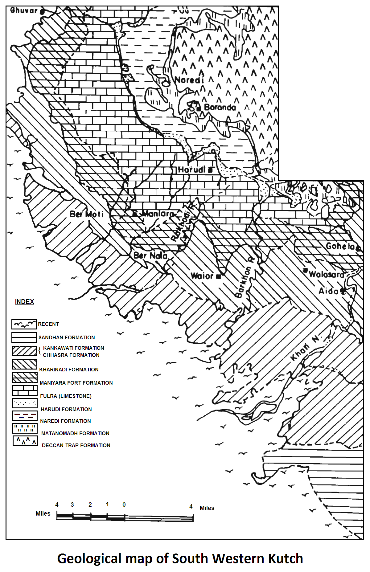
[Figure 3: Geological Map of South Western Kutch (after Biswas and Raju, 1973)]
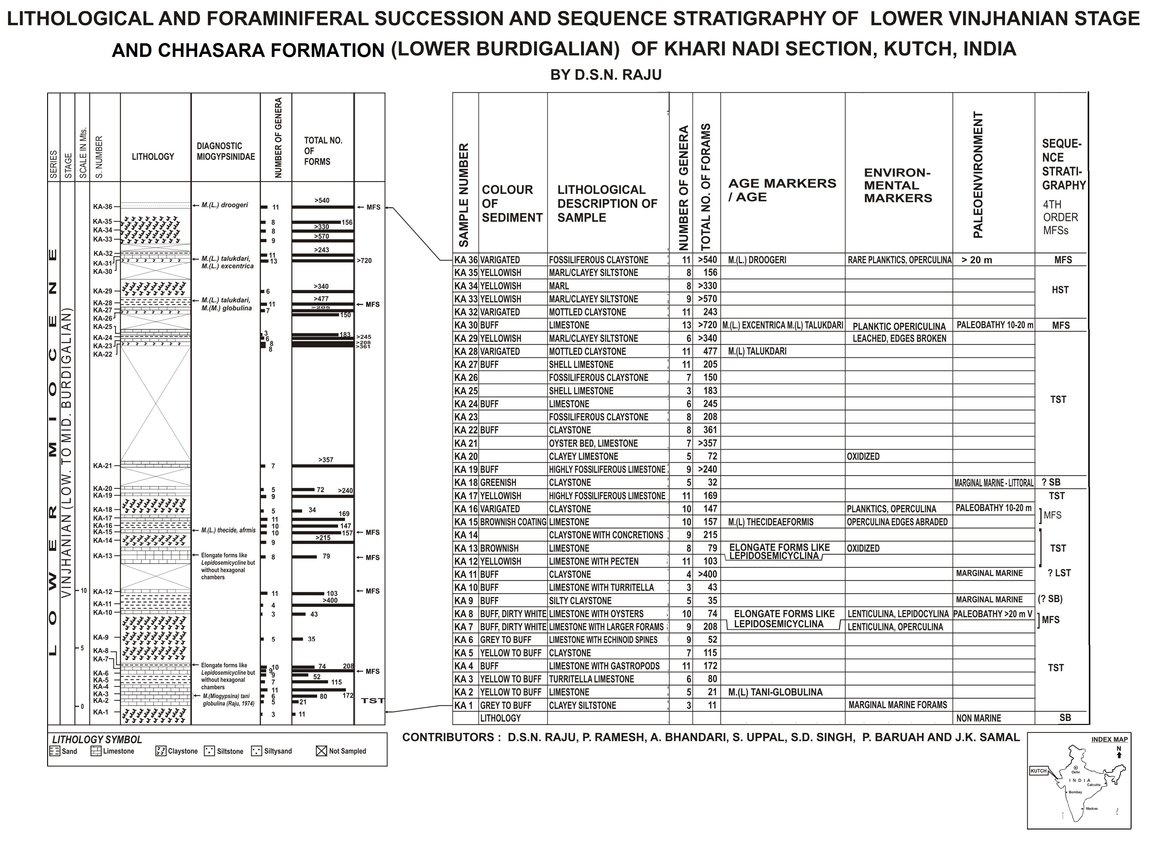
[Figure 4: Lithological and Foraminiferal succession and sequence stratigraphy of Lower Vinjhanian stage and Chassara Fm (Lower Burdigalian) of Khari Nadi Section, Kutch. (coordinated and prepared by D.S.N Raju)]
[Figure 5: The distribution of foraminiferal assemblage along the Chassara Formation. (modified after Pramod Kumar et al., 2016)]
Relationships and Distribution
Lower contact
Lower boundary is conformable with the Khari Nadi Fm.
Upper contact
Upper boundary is conformable with Kankawathi Fm; or unconformable with the Sandhan Fm.
[Fig. Sharp contact of the Pliocene-age Sandhan Formation (mainly grey sandstone containing fossil woods) and the Miocene-age Chhasra Formation (poorly fossiliferous, silty shales of marine shelf deposition) along a disconformity near the village of Mothala on Naliya Road. (Source: Rasoul Sorkhabi in GeoExpro Dec2014)]
Regional extent
GeoJSON
Fossils
The limestone beds occurring in this part host gastropods, bivalves, echinoids, bryozoans, serpulids and patchy corals. The larger foraminifera are represented by Miogypsina (Miogypsina) globulina, Miogypsina (Lepidosemicyclina) thecideaformis, Miogypsina (Lepidosemicyclina) droogeri, Miogypsina (Lepidosemicyclina) excentrica, Archaias and Soritis (Raju, 1974; 1991; Saraswati, 1995; Kumar and Saraswati, 1997) Source: (Pramod Kumar et al., 2016).
Gastropods : Turitella, Murex, Lamellibrachs: Ostrea latimarginata, O. gajensis.
Three zones/biochrons recognized are: VIN-I (early Burdigalian, early Vinjhanian) defined as an interval from LAD of M.(M.) tani to FAD of M (Lepidosemicyclina) talukdari. Latest stages of M (M.) dehaartii and variety cupulaeformis occur in this zone. Austrotrillinahowchini appears in this zone. VIN-II (middle Vinjhanian, lower middle Burdigalian) defined as an interval from the FAD of M.(L.) talukdari to FAD of M.(L.) droogeri. M.(L.) excentrica is the marker in this zone. VIN-III (late Vinjhanian, middle Burdigalian) defined by the range of M.(L.) droogeri.
Age
Depositional setting
Paleoenvironment varies from marginal marine to shallow inner-shelf.
Nine cycles/Parasequemces are recognized in the exposures.
Additional Information
